Royal Traverse - September 21, 2002

Steep craggy mountains, little-traveled, almost no beta, and a motorized approach. Is it the
high peaks of the British Columbia Coast Range? No! It is the great range of sub-5000ft peaks south
of I-90.
The "Royal" traverse
The brushy crags to the east of Mount Kent had made a slight impression in the back of my
mind. I vaguely remembered seeing them, and thinking they looked interesting, maybe for an
ascent of some of the gullies leading to the notches in winter.
Ed had recently been in the area, where he had a good view of the ridgeline,
and where he met a guy building a mountain bike trail through the area. This guy, whom we shall
call "Fred", called them the "Duke" and "Duchess". "Fred" thought the names were from some guidebook, but he
wasn't really sure. Apparently the southern peak was an easy scramble from the south, but the
others more difficult.
Ed suggested we climb one. Maybe even a traverse of all the peaks? Ed thought maybe just
the first one... he'd bring
his dogs along, while we ran up to the first main peak, and back... maybe a couple of hours?
Suprinsingly, Dave, connaisseur of pure technical alpine climbs, not sub-alpine brush-fests, was
interested too.
A suprising find in the clearcut on the approach - microbrew!

Saturday morning, and Ed had left his dogs behind out of his wife's fear that they'd run off
a cliff. Perhaps a longer day was in store?
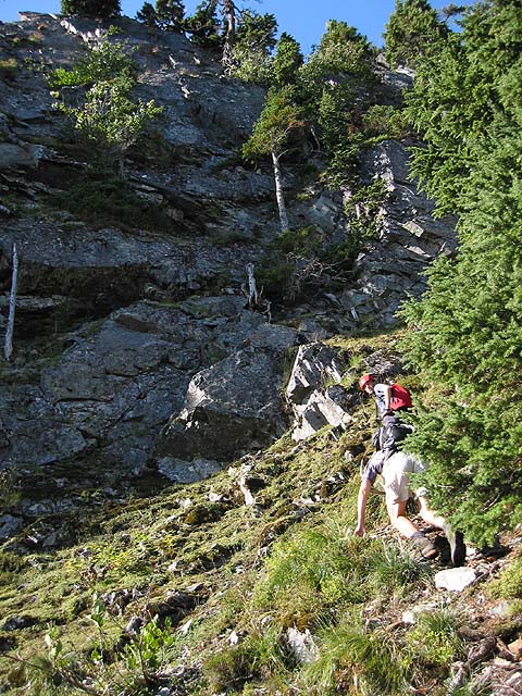
Phil gets some slide alder action on the approach.

We drove the road to where we thought we should begin. We woke up some people who were camping
here... each of us quite suprised someone else was up here. At about 8am, we hiked up the clearcut
into the woods
and soon realized, when we came upon the higher road after much bushwhacking, that
we had not parked where we intended. Oh well.
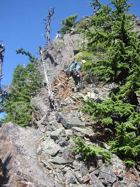
Ed approaches the notch we used to gain the ridge.

A brushy traverse, and then a talus slope, brought us to steep forest leading to a notch
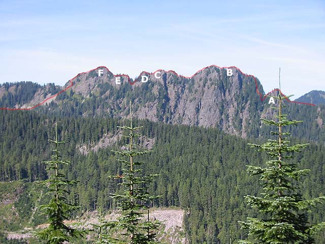
past the northernmost (small) crag. Two towers away was the first main peak (B), with a sheer
face on the left, and an "impossibly steep" forest ramp on the right. From Ed's recon photo,
this looked to be the crux of the climb - or at least the steepest part.
Dave inspects the first tower (A) for a route up the face. We ended
up on easier ground on the right
While going over the first tower, I noted all the wasps buzzing around. Shortly
thereafter, I got stung in the palm of my hand! Doh! Yo! Wassup!?? I wasn't even wearing my
dayglo yellow shirt today!
After a few 4th class-ish sections, the rope finally came out and we simulclimbed over the top
of this tower on mossy slab, then
down some talus, and finally down uncomfortable steep dirt to the next notch. Ed let loose
a huge barrage of rockfall coming down this last bit - luckily I was out of the way. Dave
wiggled the rope in an attempt to prevent it from being damaged (?).
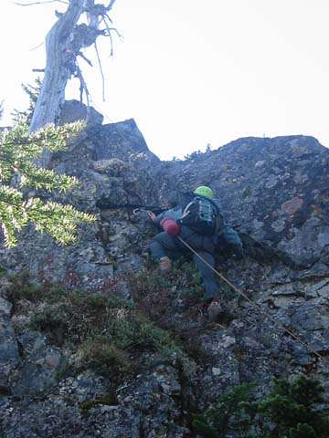
Phil belays Dave out of the notch up the second tower (B)

From this notch, Dave led up a steep dirt ramp with a rock step, then more steep
forest floor to an amphitheatre of sorts that was surrounded by shattered shards of shitty
rock. Dave spied an exit onto steep better-looking rock on the left. He led off on this
next pitch, which was about 5.6, fairly vertical but with good ledges,
and solid enough after he had knocked the loose rocks off into the empty space below him.
The crux move was made more difficult
by tree that attempted to intertwine its branches with your pack.
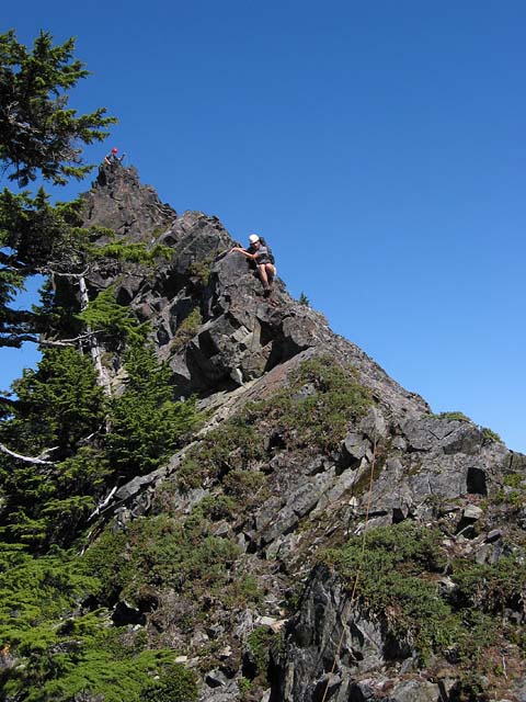
Climbing over a step just before the knife-edge leading to (B)
The terrain laid back for a while, until we reached a rock step leading to the ridge crest.
Dave and the rest of us were soon up the relatively solid 5th class step. From here there
was a final shattered 4th class knife-edge to the summit, and Ed led the way. Dave said "I felt
like the whole ridge crest was going to give away!"
This was the first main summit (B) (The Duchess), and the primary goal. Maybe it was the "Duke" or "Duchess" or
something... we didn't know. There was no summit register, so we left a makeshift one.
The view of highway traffic on I-90 and (of course) Mt Stuart, were great.
From here we could see much of the remainder of the ridge line... it looked non-trivial, including
one steep spine-like ridge-crest devoid of any trees and thus probably any pro. But returning
the way we came would be a slow proposition with many rappels, and it looked like from the map
there was a possible escape route at the next major notch.
Ed, on the way down from The Duchess, looking towards tower (C),
venturing into the unknown.
We are a little concerned by the looks of things, but somehow we found a mostly
scrambling route up it (I think on the right, though it doesn't look like it), except
for the final heinous step.

So after a food break, we followed Ed southward over the next few towers. After the slow ascent
so far, this next section went smoothly and quickly. Ed was moving! We may have passed the
"escape route" at this point, but no one said anything, since we were moving so quickly now,
the traverse was on! (Ed may have heard me mumbling about escape routes, and thus increased his
pace... it worked).
After winding around several minor towers, Ed came to a cruxy section. There didn't seem to be
a way around on the right or left of this next tower, so it was straight up. The only
problem was that straight up looked like a pile of loose blocks. Ed put in his first piece of pro
shortly before this section.
Ed gets a true taste of the Cascade sub-alpine experience.
I suppose he could have fought his way up the green carpet on the left, but he choose
instead the vertical stacked pile of boulders on the right.

Turns out, it was a pile of loose blocks. Ed kicked off a major foothold for his right foot
while he was stemming up. I couldn't tell if it was on purpose or by accident. Anyway, this left
another foothold underneath the first, and he used that to gain the ledge of loose blocks not
firmly attached to anything (the alternative to the ledges of blocks was the vertical
green carpet on the left, but alas we had no crampons or axes).
Then, as he was gaining the ledge (made difficult by an overhanging wall in front
of him), he nearly bit it, as much of the ledge gave way, and boulders went flying down into Alice Ck basin. The
smell of burning rock lingered in the air, as did expletives from Ed's mouth.
Fortunately, he was still "standing" on the remaining rocks, and quickly made his way further
right to a weakness
that led to easier ground above. He set up a fixed belay for Dave and I. Even with a top-rope,
this section was dangerous, consisting almost entirely of large moving blocks.
On this section we'd seen two rap slings, the first signs of previous parties.
Perhaps from someone traversing south to north? They weren't too faded, so probably not that old.
We took a break on this summit, and I took advantage of this opportunity to move out from the
middle position of the rope, so I could lead a bit (the next section looked like a nice solid rocky
crest).
Dave and Ed downclimb the south ridge of tower (C)
The next section indeed was probably one of the more pleasant stretches of ridgeline. It brought
down to a notch, and then eased off as we continued over another tower. Yet another deep
cleft appeared in front of us. This section had fun route-finding, and a rocky and slightly bouldery
ramp led down to the notch on the ridge side of the ridge crest, and we followed this below
the crest on the left, finding a gully leading up that had a different selection of plant life
than we had experienced so far - wet plants. But the gully was dry, and led to a meadow section
on top of the next tower. On the other side, yet another cliff face. I scoped around for a
possible route left of the crest, but when Dave saw the drop-off, he claimed we could
downclimb it.
Halfway down, I saw him pre-emptively kick (yet another) ledge of loose rocks. It totally
collapsed before
him and also disappeared down the steep mountainside into Alice Creek basin. Hmm.
Ed was next in line, and successfully climbed down to the first ledge. Then, this ledge
gave way beneath Ed's feet (Ed = 185 LBS, Dave = 145 LBS), and he was left dangling by one
arm! Lots of boulders crashing down and disintegrating!
He recovered and shouted up to me "Have you got me?" "I got you!"
The rock around which Dave had placed a sling now no longer existed, and the sling dangled from the rope...
luckily the rockfall didn't take the cam (and other things) with it!
At this point, I was having pretty serious misgivings about following this downclimb, so I said I'd
try rappelling from a this thick (but very dead) tree. Unfortunately, I didn't have enough slings
left, so Ed had to climb back up to me, and we set up the rappel together. Rappelling was
time consuming, but it sure felt like the right thing to do.
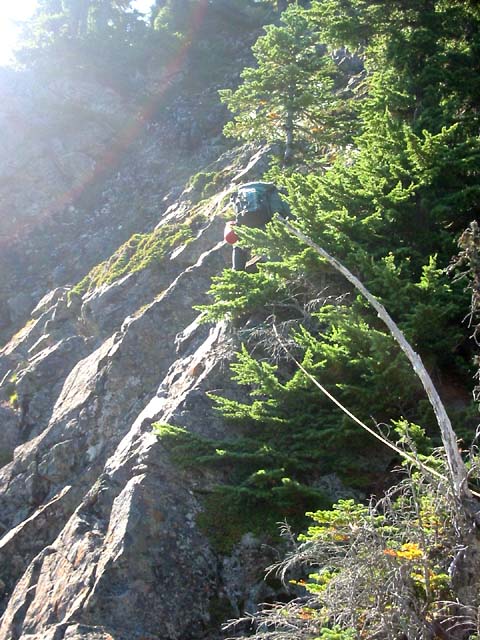
Phil finishing off a rappel down a loose step on the south side of tower (E). In
attempting to downclimb this, Ed discovered an advantage lightweight people have for this
kind of thing.
We while were setting up the rappel, Dave was waiting below. He decided to add to the alpine
ambiance by continuously trundling rocks. The smell of pulverized rock was ever-so-pleasant as I
rappelled down the loose 30 foot step.
The final ridge leading to The Duke (F)
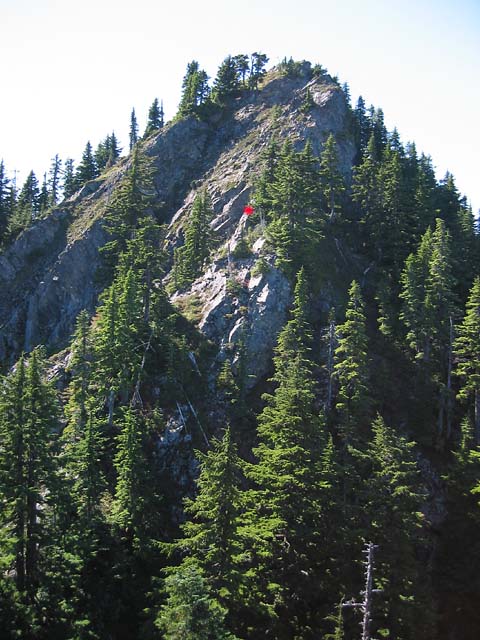
Now we were at the notch leading to the final major summit (The Duke). Dave took the lead again, and this
was probably the nicest section of climbing yet - low 5th class along the crest, and fairly solid
rock. There was even an optional jam crack near the top.
Phil, at the red dot in the previous photo.
This summit marked the end of the traverse for us. There was a summit register here... it consisted
of a small piece of paper stuck to a pink ribbon, and which had blown about 30 feet from its
(presumably) original location in a summit cairn, and was lying in some grass.
It had two names, from July 16th, and something
about "flagging the trail". Sounded like the mountain bike trail builders had scrambled up here
from the south. We relaxed in anticipation that the descent would then be straightforward.
We added our names, and placed the paper in a ziploc bag under some summit rocks.
AlpineDave (SubalpineDave?) and Ed on top of the last tower.

At a quarter past three, we left the summit and continued down the crest, eventually following a steep meadow slope far down left into talus (in the
opposite basin we wanted to be in) to round some buttresses. After some route-finding
guesswork, We found our way back up
to the ridge crest where we could drop into Alice Ck again... a couple of hours later,
after some very brushy sections of spiny plants, boatloads of talus, and some clearcut brush, we
reached the logging road and were soon back to the truck, about 10 hours after we started.
Back in Alice Creek basin on the deproach, trying to gain the logging road
in the distance. There was a patch of Grade I, BW4 on this section (a 200ft section of 35 degree dense
slide alder infused with an complete array of spiny plants, including, but not limited to,
Devil's Club).

#3 camelot, and 2 smaller cams
3 nuts
Lots of slings