
Nason Ridge, April 8, 2000
Matt, Greg, Nathan and Phil find fluffy powder on a hot spring day...Our intention was to ski the chutes off in the background. Due to the fact that the chutes on this day either consisted of avalanche debris, or cliff bands, we changed our mind.
The spirit of wilderness adventure juxtaposed with the neo-modern architecural aspects of civilization

This short slope consisted of a foot of powder! We gave up trying to continue to Rock Mtn when we started experiencing face shots.

Matt jumps a small cornice.

Matt getting a face-shot,er, face-plant

Our bowl began to look pretty tracked up after the third run.

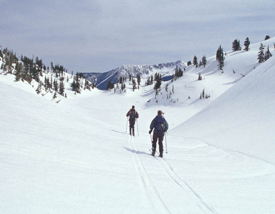
Rock Lake, and the beginning of the adventurous descent down Schilling Creek.
Greg rips up the awesome alder slope above highway 2

Nathan does the same
Trip summary:
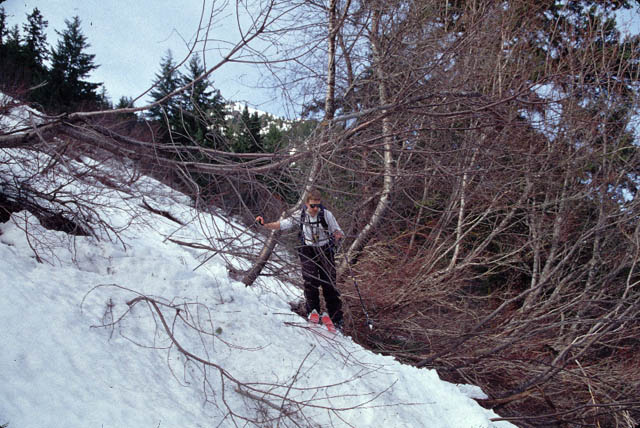
Our idea of skiing the steep chutes of Nason Ridge above the DOT facility was already looking to be not so great with avalanche forecast (though we had left Seattle at 5:30am to try to "beat the sun"). However, when they came into view, they were either chock full of avie debris (and thus would be a very unpleasant ski) or had cliff bands. Oh well. Our backup plan was a tour to Rock Mtn. Burgdorfer states that the approach to Rock Mtn is "continuously steep and exposed". This turned out to be correct. Luckily, there wasn't that much snow on the ridge, at least at first. Higher up, the snow became continous, and starting to get slushy. We knew it would be an interesting descent. It might be difficult to pick out a safe "treed line" on the way down. After about 2000ft of climbing, we remove the skis from our backs, and placed them on our feet, and proceeded to find a relatively safe route to the ridgetop above the lake. The views of the Chiwaukum Range were amazing... looks like lots of good skiing. We also had a clear view of Jim Hill Mtn, and a few very distinct ski tracks spanning the face top to bottom. And right in front of us, the terrain around Rock Mtn was excellent, although much of it was very steep south-facing stuff, and out of the question for this day. From where we were, the continuation to Rock Mtn looked a bit suspect... we needed to climb a steepening slope under some big cornices. Putting off that decision, we checked out the 400ft slope below us, leading down to the basin of Rock Lake. Our secret hope of north-facing powder came true! In contrast to the deep slush on every other aspect we had been on so far, the sheltered north slope consisted of almost a foot of fluffy stable powder! We enjoyed ourselves, and our multiple face shots, so much that we never bothered to continue to the peak (although from the map it looked like we would have found even more extensive north-facing slopes). The powder runs were short, but very sweet, on this hot sunny day. The big snowfield we could see on Jim Hill was at a similar elevation... we got a bit jealous thinking whoever made those tracks over there might have powder like us too... except on a much longer slope! For the return to highway 2, we decided to ski out via Schilling Creek, instead of the ridge. The sloppy snow was a bit tricky, as we made our way between bits of open slope. We didn't want to commit to skiing the streambed, since we didn't know the terrain, and we could see areas that were open water. We kept to the side of the gorge, and got cliffed out at one point. Backtracking, we finally made it to some slightly less exposed sidehill traversing (made somewhat sketchy by the tendency of the top 8 inches of slush to slide off the icy base), and eventually to an alder/avalanche slope near the highway. The snowpack got thin here, but we were able to remain on skis all the way to highway 2.