Little Tahoma, NE Face partial descent - May 30, 2005
It started with a 1:20am departure time from Seattle. My alarm was set for 2am, but I was too excited to sleep, so I left earlier. The skies were cloudy and drizzle fell as I drove to Enumclaw. By the time I reached the trailhead, the rain had stopped, but the skies were still overcast. Sleepiness beat adventure-in-waiting, and I napped for half an hour or so before heading off.
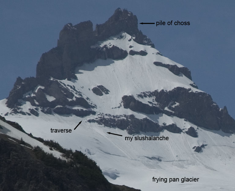
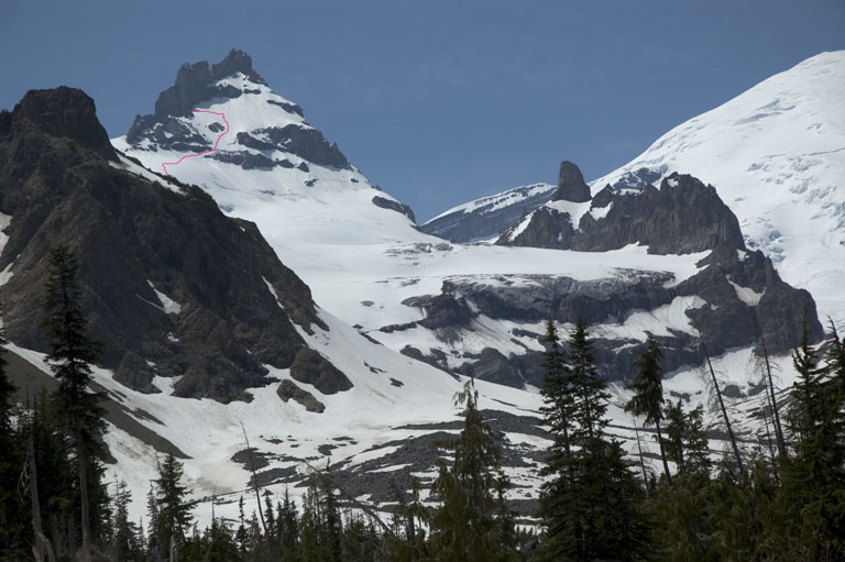
As I marched along the 4 miles of dry trail, the skies lightened, and the dark silhouettes of the peaks to the south emerged from the mist, etched with slivers of dirty spring snow. The first views of Little Tahoma presented themselves. A key to my plan was the presence of a ramp of snow through the lower cliff band on the face. Photos I'd seen from early May made it look like it was nearly melted out. What would it be like now, three weeks later? From a distance, it still looked like there was connecting snow.
As I hiked up a gully leading to Summerland, snow started to appear. The skis finally moved from my backpack to my feet when I needed to make a crossing of undermined snow that bridged the creek. Today was my first day on new gear: K2 Shuksans and Garmont Megarides. The Megarides felt much stiffer and more restrictive than my TLT4's. Probably a good thing?

When the slope steepened above Summerland, I switched to booting again, following an old, curiously zig-zagging bootpath to prevent post-holing. There was a slight crust on the snow, but it was slushy underneath. A stiff breeze made me wonder if snow would be slow to soften higher up (little did I know, nothing could be further from the truth). The rich hue of the rising sun soon faded to the blander, colder daylight colours. Near the top of Meany Crest, the footprints in the bootpath were sometimes thigh-deep! Oddly, they kept close to rocks, which surely only worsened the wallowing and made me question the wisdom of their creator.
At point 7573, I passed a lone figure in a tent. He made no attempt to engage in conversation at this early hour, and so I kept quiet too. I followed (fresh?) tracks through feeding iceworms, across the Frying Pan Glacier, but soon left them as I thought they traversed too high. I rejoined them again shortly before the 9100ft notch that leads to the Whitman Glacier. I heard voices from above, and four climbers appeared at the notch. They were dressed in heavy clothing, in contrast to my shorts and T-shirt. As we passed each other, they noted my superior method of travel as they sunk to their knees with every step. They said they had turned around, but that a different party had made the summit the previous day. As I reached the notch, I looked back down and heard them determining conditions were not suitable for glissading on the sloppy 20 degree slope, as their attempts led them to be motionless.

After a short break, I made a gentle rising traverse to the Whitman headwall, passing above a large pile of fresh-looking avalanche debris. Upon closer inspection, the slightly rounded chunks suggested it was probably a few days old. Lucky for me, the avalanche had left a firmer surface for booting, as it was now too steep for easy skinning, and the skis went back on my pack. The slope above flattened convexly out of view, so I could not see the source of the avalanche until I reached 9800ft or so. It had started at the top-left of the Whitman headwall, and there was a clear fracture visible. Along the path of the slide, a good 2 or 3 feet of the snowpack had been removed.

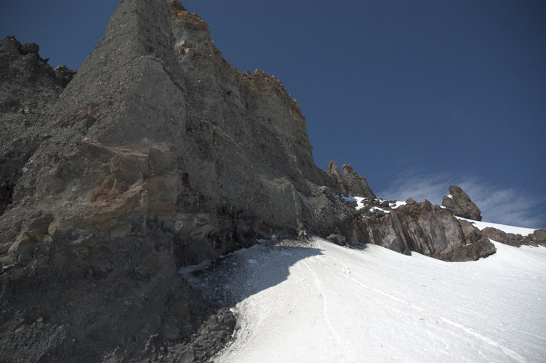
My pace slowed considerably as I headed right on gentle slopes to a notch above the NE face. I had reached the 10000ft "energy-wall" of a lowlander, and it took me almost an hour to climb 600ft. I side-stepped up a final slope of wretchedly saturated slidely "snow".
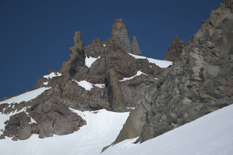
At the notch, I admired the amazing chosiness of Little Tahoma. Seemingly overhanging spires of mud-encased boulders rose above me, undercut with secret alcoves. There was the usual small rockfall, but nothing particularly worrisome.
I decided against heading higher up the face. There was probably 400ft of skiable terrain above me, but it involved crossing to the other side of the face to access. I thought that would take a while to get over there in this sloppy slop. Meanwhile, the sun was baking the oven even further. Best to just get down?

I began having pangs of doubt about the wisdom of skiing down to the lower cliffband - I would basically be committed - I sure wouldn't want to have to wallow back up this rockfall-threatened face.
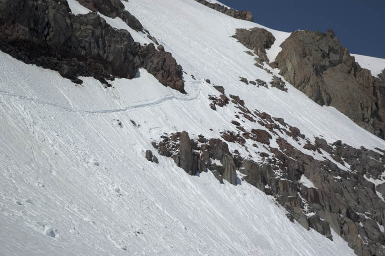
But soon my skis were on, and I was traversing out to the middle of the slope, and my Shuksans started making turns! I couldn't get any snow to slide, and the skiing was easy, soft and pleasurable - and yet also quite titillating with my position. As I approached the cliffband, the exposure became more noticeable. Here was the cruxpoint - it all looks different now! What if I can't find the ramp? All I could see was a line of rocks above air.

I inch down the most likely place, and am relieved to see the ramp, covered well-enough in white. I side-slip tentatively down it, and find the snow here is much slushier (warmed by rocks), and very happy to slide off. If I push at it with my skis, I feel it release and pull them down with good force - yikes!
A little side-steeping gets me to a clear shot out, and I push off. The snow around me is collapsing, but my forward momentum carries me off the face. I look back to see a large amount of slush pouring over the cliffs, and for a second think "Cool, I'm in a TGR movie!".
Relieved to be on easy terrain again, I realize I had been all worked up about what actually turned out to be a pretty mellow ski! I make turns down a nose of wind-rippled snow, happy about the performance of the Shuksans on the slightly crusty surface. More cliffs appear below, and I have to consult my map to figure out I should head left.

I had scoped out a crevasse-free way down earlier in the morning, but now below me I see a crevasse stretching right from rock band, left to ice cliff. Hmm? A few more turns, and I see a snowbridge which I take across. Had I actually been in a TGR movie, I would have hopped it of course.
Now I cut across the top of the Frying Pan in a mile-long descending traverse. Just before point 7573, I cut left to the steep slope that drops to Summerland. These are sweet turns! The snow is much more consolidated at this elevation and I can really let loose on the beautiful smooth slopes. I ski to 5600ft, a continuous descent of 4800ft from my highpoint. Current time was 11:30am.
To get out, instead of dealing with valley brush, I skin a few hundred feet back up to Summerland, and descend the stream gully, reaching the valley bottom where the trail emerged from under the snow, at about 5400ft. 4 miles later, I am back at my truck.