Liberty Ridge, June 15-17, 2000
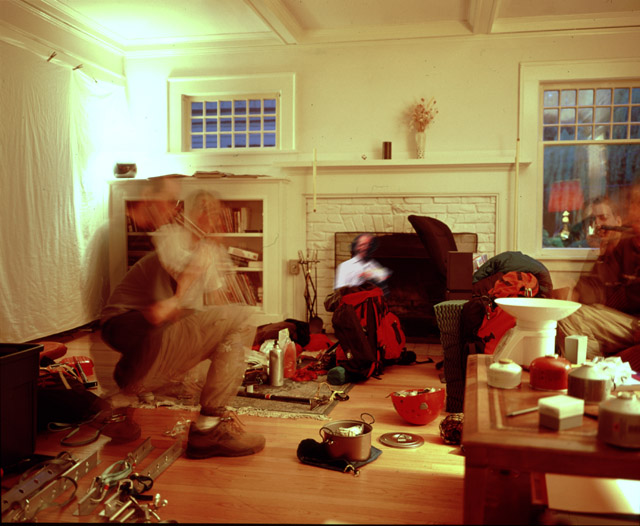
Marcus's version Dave's versionPre-trip meeting at Phil's house. Note the kitchen scale.
Marcus, Dave and I arrived at our camp spot on lower Curtis Ridge (7200ft) at around 3:30pm Thursday afternoon, approximately five hours after leaving the White River campground. Today was the first sunny day after over a week of bad weather, including several feet of snow above 5000ft (the previous weekend, the summit temperature had been below -20C, with 40MPH winds). We had expected the avalanche danger would be rather high, and, as expected, the friendly ranger had said it would be too. Apparently earlier in the week, a "class 4" avalanche had ripped from near the summit, at 14000ft, down to 9600ft on the Winthrop glacier, even covering the area around Camp Shurman with snow dust. I had hoped that the warmer temperatures and rain a few days before would help consolidate things, and perhaps high winds on the upper mountain would help up there.
Dave on the approach, at St. Elmo's Pass
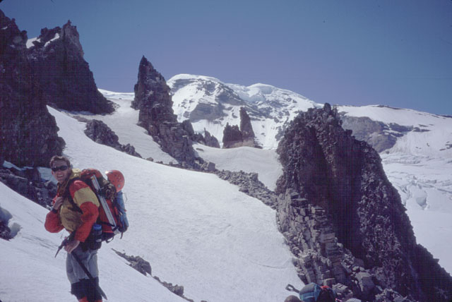
So far, things had been looking good though. We had arrived in Glacier Basin, and buried our beer cache in the snow under a notable tree, to be retrieved on the descent. The surrounding slopes had avalanched recently, as evidenced by the large debris piles everywhere. However, it looked like there wasn't much left to come down, and the snow was firm and good for walking. We had passed by the "Yellow Hill of Death" and ascended snow slopes to the top of St Elmo's Pass, where we had roped up for the crossing of the Winthrop. We hadn't been able to see any evidence of the class 4 avalanche that had happened.
Traversing across Curtis Ridge
The Winthrop had been fairly straightforward, but then we were faced with the "widest ridge in the world", lower Curtis Ridge. It went on and on, until we had finally reached the west edge of it, overlooking the Carbon Glacier, and the north side of The Mountain.
Here were some nice carved out tent platforms, and a father and son team from Denver, also intent on climbing Liberty Ridge. The day was cool, but sunny and not too windy. The father and son team told us that the upper mountain had been in the clear when they flew in on Monday. This was promising... it may have already received lots of sun.
Hans Burdick and Frans Fortier at Curtis Ridge camp

We relaxed, ate and drank, enjoying the impressive views, closely examining Liberty Ridge. Later on in the afternoon, a group of four arrived and set up camp a hundred feet away. We had initially met them at the trailhead - we had left at the same time, but it had taken them a few hours longer than us, due to their heavier packs.
The summer climbing season has begun, and that means my handy-dandy scale comes to the trailhead. Before we left, we had weighed our packs, which ranged between 38 and 42 pounds, all included. The group of four took advantage of the scale, and yet seemed none too dismayed that their packs averaged around 50 pounds, with one guy as high as 55. "Haha!" we thought. The one exception, with a light pack, was their leader/guide, Mr. Positive. Exactly. Totally. Yup. Niiiice. Yup. Totally.
Later that evening, we took a walk form our camp to scout out the route up the Carbon to the base of the ridge, for tomorrow. There were some old tracks that we followed through a small icefall, creaking in the late day sun, to a flatter spot, where we could see a long section of straightforward glacier. It was hot and windless down on the glacier. Another group could be seen camping in a large flat area. We had watched them hike further up the glacier, presumably to scout it out. They had returned, but they were too far away, and we too lazy, to walk over to them and get their beta. At any rate, we had seen a climbing team near the top of the ridge earlier in the day, so presumably the Carbon was crossable.
Afternoon walk on the Carbon

After a "pleasant discussion" of what time to leave the next morning, the watch was set to 5:30am. We figured we had 4 or 5 hours of climbing to get to our next camp, at Thumb Rock (10760ft, right Marcus?), which would be best done in the early hours.
View of Willis Wall and Liberty Ridge from our tent

Day 2
The next morning found us cramponing up the Carbon on hard snow. I led the way through the icefall this morning, which was suprisingly, still creaking. We passed by the snow wall built by the glacier campers. They were gone. Faint crampons indentations in the snow revealed they had left at an early hour.
The route meandered though terrain that became more and more crevassed the closer we got to the ridge. Finally, the ridge looked only a hundred yards away. Another 15 minutes, I thought. It turned out to be about 90 minutes, as the route became a circuitous end-running affair, with some thin snowbridges that would be undoubtedly very sketchy in the afternoon. One was about 10 feet long, 2 feet wide, and only 1 foot thick at each end where it connected to the crevasse walls! A missed step would mean a plunge over a hundred foot drop (which, of course, would have been arrested by one of us).
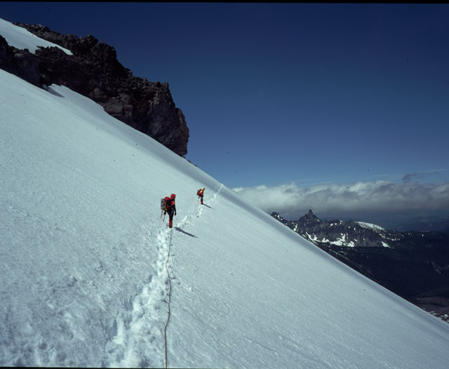
Marcus and Dave on the bottom of Liberty Ridge

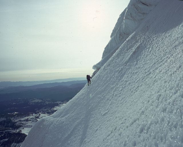
We took a break at the base of the ridge, and then Dave led up some class 4 dirt and rocks to the moderate snow slopes on the west side of the ridge. After half an hour of climbing, we crossed the ridge crest and moved onto the sunlit east slopes. This was to avoid having to descend to get around a rock band on the west slopes. I was last on the rope, and it seemed to take forever before I reached the ridge crest, and stepped onto the east side. Sketchorama! The snow instantly turned from nice freezer ice consistency, to a 45 degree slushy! The exposure was, needless to say, quite exciting, as we traversed alongside some rocks, with a straight shot down to the Carbon on our left. Occasionally we punched into our thighs, and footholds sort of collapsed. One picket was placed in the slush, but I doubt it would have held a fall. A short distance later, we reached some rocks and had a rest. I then took the lead and continued back up to a col on the ridge crest, trying to gain the cold west slopes again. If this didn't work out, it looked like we had lot more 45 degree slush to cross!
Tension grew as I neared the col. Looking over the other side, things looked... pretty good. After yet another break, we continued across some rocks and dirt to a large snowfield that I hoped would take us up to Thumb Rock. Hmm. I think I heard some "complaining" coming from behind me as we crossed the rocks, and a suggestion to instead head directly up the rotten rock of the ridge crest. Huh??? - steep rotten volcanic rock, or firm snow. I'll take the snow, thanks.
Now we finally settled into some fun, exposed, firm, smooth, 40 degree slopes leading a thounsand feet or more up to Thumb Rock. I had heard so much about Thumb Rock in stories I had read about Liberty Ridge, and here it was, coming up!
Marcus and our camp at Thumb Rock
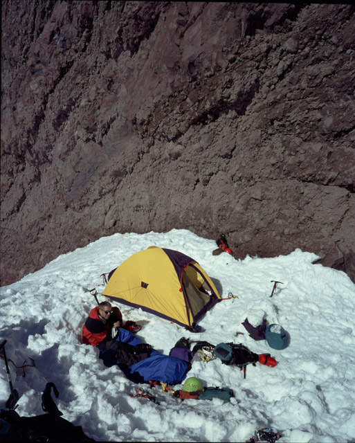
Situated at 10760ft, supposedly there was only flat spots for a couple of tents. Otherwise, you had to dig platforms out of the steep slopes - assuming there is snow on them. I imagined the wind could just howl through there. How exposed was it?
The slope mellowed slightly and we finally walked into camp, just over four and a half hours after starting out. There was a group of two around the corner, at one of the flat spots. We sat down at the other. Yup, pretty much as expected. However, there is room for a lot of people on the 30 degree slopes immediately above Thumb Rock.
We had gotten lucky with the permit situation. Unaware that high camp quotas were now in place almost all over The Mountain, we hadn't bothered to make reservations for Curtis Ridge and Thumb Rock. When we had walked into the ranger station the previous morning, we had gotten the last spots at both camps. Verrrry close! Thumb Rock was "booked to capacity" this Friday evening, as shown on the ranger's computer - 11 people in 4 parties (actually, the limit is 12 people).
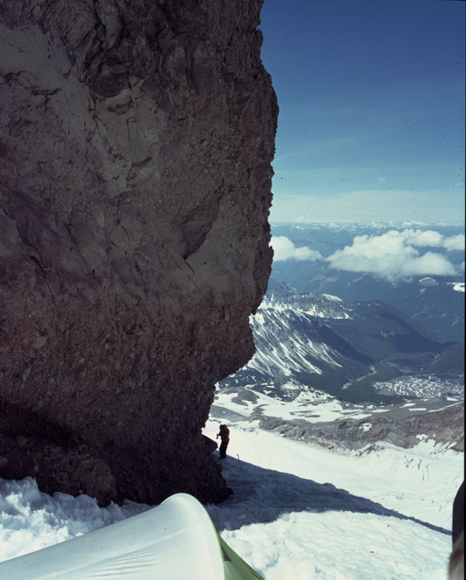
Thumb Rock itself is a toterring tower that looks like it's made of a mixture of mud and rocks. It's probably 100-200ft high, about 15 feet wide, but only 10 feet wide at its base. Both sides overhang, near the ground.
Dave looks at the route above Thumb Rock.

Dave offered some Thumb Rock trivia. "Apparently, it's been climbed."
Though it was vertical and overhanging, it didn't look ridiculously difficult, as it is very blocky. However, protection would be non-existant (maybe pound a picket in???). And it looked as if a good strong wind could come and blow it over. Or maybe if you removed a rock from the base, it would topple.
We looked for the best place to set up camp. There was a nice spot dug out just above us, but beside it was a slightly-smaller-than-breadbox-sized rock that must have recently fallen from above. We decided right where we were was the best spot. It was right underneath Thumb Rock, but the rock debris littered about was of a smaller (baseball) size.
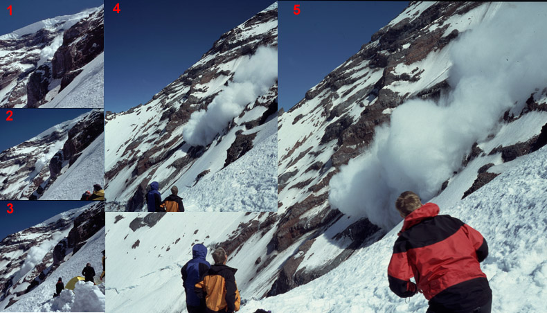
An avalanche off Willis Wall. The thing that suprised me most about these, was their relative silence. On the North Face of Shuksan, Matt Cary and I were regularly started by explosive noises, only to look and see a relatively small snow slough slide off beneath some rocks and plunge over a 400ft cliff. Though impressive, the visual impact was much less than the thundering loudness suggested. On the other hand, here on Willis Wall, after the initial ice cliff crack, these huge billowing clouds of snow were silent by comparison, until the debris they produced gathered mass and fell down the lower slopes of Willis Wall.
It was remarkably warm and not windy. We spent the afternoon lazing around, melting water, eating, talking to the other parties arriving, using the blue bags, watching avalanches come down Willis Wall, eating, drinking water. THIS is what mountaineering is about!
At Thumb Rock that evening were a total of fourteen people: The group of four with heavy packs (they took about 2 hours longer than us to get up here); the father and son team from Denver. A group of two from Wyoming (They were already here when we arrived. They were spending an extra day, after getting too late a start this morning.) One of them had climbed Cassin Ridge on Denali.
There was also a group of two that Dave knew from BOEALPS. They were permitless! haha, so evil. And finally, a solo climber walked into camp in the evening. Crossing the Carbon Glacier alone!!? Yowsa!
Dave analyzes Mr. Hankie trapped inside a blue bag east side of Thumb Rock. It was prudent to take your ice axe with you when you went to the bathroom, or you could be in a for a wild ride 2000ft down to the Carbon. We were very careful not to touch the overhanging choss of Thumb rock.
Sleep came fitfully that night. Almost not at all. After watching some odd movements in the Wyoming group's tent (ala Four On The Floor's the People Inside Your Walls), we hit the sack around 5pm, since we planned to get up at midnight. The guided group of four, however, were the only ones not on a similar schedule. We got to listen to their entire meal-eating, tent-platform-digging, conversationing, rigamorole (they were planning to rise at 4:30am). Every once in a while, one of them would note that everyone else was in their tents, trying to sleep. And they'd say "Hey, we should be quiet". Then, a second later, that thought would be forgotten, and we'd hear "How many cloves of garlic do you want?", or "Keep goin' with that water melting. You da water-melting MAN!", but mostly "Totally.", "Yup", "Niiiice", "Exactly".
We heard their guide explain that tomorrow they would be using a different rope system than they had used for glacier travel. The three would all tie in 15 feet from each other, giving the guide enough rope to lead a good section of slope, and then he would belay them up to himself and repeat.
We were a little scared for them (not that what they were suggesting to do was dangerous, but it showed the relative inexperience of the other three, and would mean spending a looong time on the ridge).
Throughout the night, I occasionally heard a nasty hacking cough. It sounded like it was coming from right outside the tent, i.e. Marcus, who had been delegated to the bivy sac this evening. I hoped it wasn't Marcus, developing HAPE!
I finally started getting some good sleep at about 11:30, a half hour before we were to get up. At midnight (or actually, 11:59pm, since Marcus just wanted to be _sure_ about the am/pm situation, and 12:00 is a very suspicious time indeed), the watch beeped. I sat up.
Here we go, this is it. We're climbing Liberty Ridge today.
I tried to rouse Dave, but to no avail. A stern finger-poking was needed... hey, no fair that someone is getting such good sleep!
Day 3
Out in the darkness, we got Marcus up, a slowly prepared our gear. The night had been nearly windless, in stark contrast to the 70MPH winds the night before. Well, that's how strong the Wyoming people claimed they were anyway. Perhaps 70WMPH (Wyoming Miles Per Hour). Only a light breeze occasionally below across Thumb Rock this fine morning.
Just after 1am, we set off... the Wyoming guys, still cooking breakfast, wished us good luck. The BOEALPS people had just started to stir.
Phil near the rock step

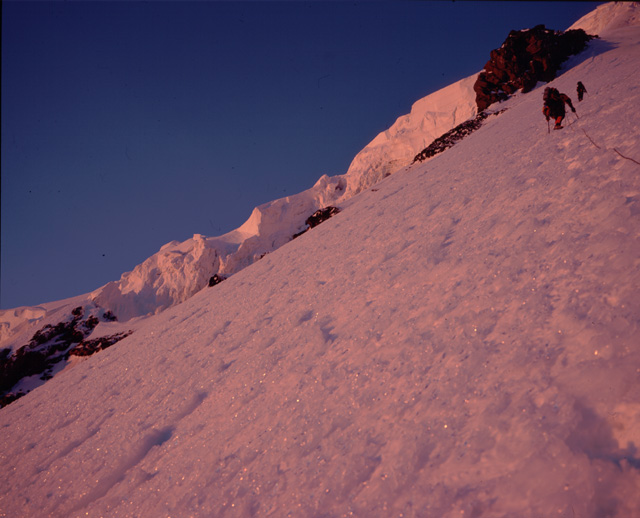
After discussions the day before, we had decided not to take the standard route, which heads up to a 10ft rock step, into a 45 degree gully. The step, sometimes covered with good water ice, was only partly so, and as such, would not be that pleasant. Instead, we headed slightly left, on a steep rising traverse to circumvent the rock outcrop above Thumb Rock. Dave led the way up in the darkness. The lights of Seattle and Puget Sound could clearly be seen over to the northwest. So damn beautiful! Moonshine was illuminating the lower north slopes of the mountain, but the moon was too low to help us up on Liberty Ridge. We could just make out the snow slopes and rock bands in the starlight. Perhaps this was good, as the thousands of feet of exposure beneath our feet weren't quite visible.
The snow was in great condition, with the occasional foot trail to follow, making things a little easier. We flatfooted up slopes 40 degrees or steeper, stopping whenever the angle would allow it, which was only very rare. Not really any place to relax and take a break, you had to anchor yourself to the mountain with your ice axe each time.
I had stuffed my pockets with packages of GU, recommended by both Marcus Collins and Mark Twight. How can you deny that, I ask? I didn't really feel like eating anything else... GU was just right. My water bottles were strapped to my sides, so I didn't need to take off my pack for the ascent, which is a good thing. Marcus had a platypus system going... I had made my feelings known on those things (platypus, camelbaks, dromedaries)... they are evil, leaky things. However, I must admit, I was thinking it would be pretty nice, not to have to deal with delicately remove my water bottles from their holders, taking care that they don't fall don't the mountain (I know, I know, I could have clipped them in with string), and then struggling to fit them back into the holders while trying not to fall of the mountain myself. This was the first time any of us had been on such a relentlessly exposed slope, with no place to stop and spread your stuff out. Hmm, yeah, a Platypus would be kinda nice. However, my disdain of camelbak-type water resevoirs would once again be reinstated higher up, as Marcus' tube froze in the cold night air, and he was no longer able to drink from it. Haha!
Diagram of our route

Route-finding started becoming an issue in the dark. We could only vaguely make out the intricacies of the snow slopes and rock band barriers. Finally, we stumbled upon a set of tracks from the day before, well entrenched into the hard snow. They must have been up here fairly late in the day.
We neared the Black Pyramid, and the rock outcrop below it. Dave led towards the ridge crest, thinking this was the time to cross to the east side. He peered over and looked around. From my position at the end of the rope, the only other option I could see was a frighteningly steep traverse off to the right, to get around the next rock band, and onto the snow band below the Black Pyramid, that definitely led to the final east slope. I wanted to know what was going on. Marcus echoed my desire up to Dave, but Dave yelled back that he was engaged in some route-finding, and did not reply. I was getting pretty nervous, and began thinking about our exposure. Standing around on a 45 degree slope in the dark, looking down into the murky depths of the Carbon, with vague outlines of rockbands above, was pretty unnerving.
Finally, Dave traversed carefully right, just beneath the rock band. Was he going for the long traverse? Instead, he placed a picket, and climbed up over some rocks, to another snow slope. We began moving again. Another picket, over another smaller rock band, and up another short snow slope, brought us to a relatively flat (35 degrees) spot on the snow/rock interface on the ridge crest. Here we took a short break. During the past half hour, we had seen headlamps moving up towards us from below.
Sunrise, high on Libery Ridge (Marcus and Dave in the top right)
From here we traversed left on steep snow, and moved slowly around left of some rocks, on the steepest section of the route, approaching 50 degrees for 100ft or so. We placed a few more pickets here, and the sky started to brighten. Above this, the slope began to mellow significantly, to around 35 degrees. Two parties caught up to us - the BOEALPS guys and the Wyoming group.
At this elevation, the slope began to turn into this nasty bumpy water ice crust. It sucked to walk anywhere except where steps had already been kicked. We let one party pass us; the other one sort of wanted to, but there was no room. The two from Wyoming were an interesting pair. The guy in front was obviously feeling a little faster and more energetic than the second guy.
"Don't shake it! Don't shake it! Keep climbing!!", he yelled at his partner.
The ascent now turned into kind of a slog. The altitude started making Dave lose his steam, and we slowed as we ascended to the flattish area (again, remember that on Liberty Ridge, flat = 30 degrees) below the final bergschrund slope. The going was tough here due to the bumpy ice. We finally sat down at a truely flat spot on top of a small ice fall. Both the BOEALPS guys and the Wyoming guys decided this was a good time to take a dump, or so it smelled.
From here, we had a good look at the options. A set of tracks was visible, traversing closely underneath some icecliffs on the left, then angling right across the final steep slope, to the right side off the bergschrund, which looked like a step across. The traverse looked steep, and the snow/ice looked very bumpy and disgusting on the left, so as I took the lead, I decided to try a more direct route through a break in a another set of small ice cliffs, and then to the 'shcrund.
We ascended up a steep little step, through a draw where the Wyoming guys were taking a dump, and then across the ice (it had looked like smooth snow from far away, but it was not) towards the cliffs. The terrain here was around 35 degrees. The BOEALPS guys had the same idea, but they got there slightly ahead of us by another route. Only very slightly ahead of us. Like 10 feet. However, those 10 feet meant that they would get to climb through the cliff first, and we would have to wait.
They seemed to take forever, though there was only two of them. I think we waited below for about half an hour. During this time, ice chunks melted of the summit slopes occasionally pelted us, followed by chunks kicked off from the BOEALPS guys. In my haste to get to the cliff before they did, we had set up shop too closely underneath them.
Phil trying to hammer in a picket on the ice cliff
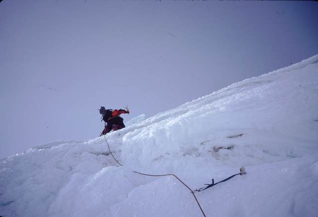
Finally, when they had moved on, I banged in a picket and two-tooled up over the ice cliff. This was the first time a second tool was truely necessary (although it made all the other slopes much more secure and efficient) Above, I tried to hammer in another picket, but it only went in a third of the way. I decided to try an ice screw, but I knew as I wound it in that it was no good. Returning to the picket, I managed to hammer it in halfway, and clipped it off, and belayed Marcus up. During this time at the belay, I saw the Wyoming guys traverse in from the left, across a frighteningly steep slope. They occasionally were yelling at each other, as it sounded as if one of them was falling.
Anyways, back to us. Finally, Dave, sick of being constantly pelted by ice chunks, arrived up with us, took 3 pickets, and headed off to the bergschrund.
Here, people's attitudes started to deteriorate a little. The solo climber had now arrived and passed by all of us, and crossed over the bergschrund with the BOEALPS guys. They appeared to be kicking down ice chunks on us from above. We started yelling up to them to stop... it was actually pretty frightening. Half our time was spent crouched on the ice, helmets uphill, listening to ice chunks whizzing by, occasionally getting whacked by one. Me on my shin, Dave on his hand.
Where we didn't go (we went up an ice cliff instead)
One of the Wyoming guys, who were sort of intertwined with our rope, started screaming some incredibly colourful language, explaining what he was going to do to them once he got up there, if they didn't stop. They yelled back that it was unavoidable. A screaming argument ensued. Everybody was screaming. Ice chunks were flying. We wanted to get out of this place. Relative safety was so close, but it seemed to be taking forever to get there.
We kept moving as quickly as possible, putting in more pickets because we were getting damn tired, things were kind of crazy. I finally arrived at the bergschrund, which was a one move vertical step, and then I climbed up toward Marcus and Dave. As I did, I finally realized that we had done it... Liberty Ridge.. and this was also my first time on top of Rainier - and my eyes welled up, and I couldn't really control it. Never had such powerful emotions on a climb before (luckily my sunglasses hid all that, huh!?) As I got to them, we hugged, and I flopped down on the final gentle slope leading to Liberty Cap. Wow! I realized I'd probably look back on this one day, and say, that wasn't so hard. Haha... But man, it was pretty damn challenging, all things considered - packing light, the physical exertion, dealing with the unrelenting exposure, the fear, the altitude, the flying ice. And here we were - yeeeha! The mountain gods had blessed us with good weather and good snow conditions... thank you!
Marcus tops out on Liberty Ridge
We climbed up over more bumpy ice, passed over Liberty Cap, and descended to the basin/ridge between it and the main summit. Here, we were out of the wind, and the sun beat down. We took an hour and half break, melted water with the Primus (which had a little difficulty with the cold, as it was below freezing, but Dave got it to work). Marcus tried to phone home (to no avail), Dave brought a Mr. Hankie into the world, and I sucked down some more GU.
We wondered what ever happened to the father and son team, and the guided group of four.
Relaxing on the summit plateau
And now it was down... 10000ft down to the truck. The Emmons was a slog. The longest slog. There were about three crevasses to step across, but other than that, it was a 30 degree snow slog. None of the parties we passed by seemed to be enjoying themselves. Occasionally they asked me how high they were, how far to the summit, and I gave them some quite discouraging answers! Things got soft and deep as we approached Camp Schurman. A cloud cap formed over the mountain on the way down, but then dissipated. We took another long break at Shurman, and the climbing ranger gave us water, so we wouldn't cook on his doorstep. 5000 more feet to go ... down to the Inter Glacier in the hot burning sun, and some crazy roped glissading/towing/flipping antics, much to the chagrin of the hopeful summiteers we zipped by, humping it up to Camp Schurman.
More plodding brought us to our special trail, which in turn brought us to our beer cache in Glacier Basin. The "gramarnier" was brought out, the beers were opened, and the small amounts of alcohol turned us dehydrated climbers downright silly. Especially Dave, who yelled out "Cheers!" to every one who passed by on the main trail a hundred yards away. Marcus started seeing "people" everywhere.
"Look! People!", he would exclaim.
And we would look up, and our foam pads would slide forward, knocking us off balance.
Celebrating at the Beer Cache

Another hour or two found us at the trailhead, packing up, and trying to find the drop box where we were supposed to sign out. We headed to "The Mint" in Enumclaw, based on the suggestion of the Schurman climbing ranger, but though we tried to deny it, pretending nothing was wrong until the last possible moment, after we had all ordered our food, after Marcus and I and had been carded, after Dave was asked for his ID, and why would anyone ask unless you had to be 21, and Dave presented his ID, and the guy looked at it, and announced his age, and we had to leave.
So we ate at a Mexican/American restaurant in a Best Western. I had the American. It was pretty good. And of course, some lemonade. But it was from a can, not fresh-squeezed, like you can get in Boston, according to Marcus. I don't believe him.