Mount Garfield - August 19, 2001
I heard Loren shout, and quickly looked behind me. The rocks beneath him had started to let loose - I bolted
out of the way, and saw him slide down on top of them, in a cloud of dust. Large chunks went bounding down
the #2 gully on Garfield's south flank. He seemed to be riding the largest rock for a long time,
even though it only slid down about 10 feet. When everything stopped, it looked like he was OK, which
he verbally confirmed. I scrambled over, and pushed on the double-breadbox-sized rock that had him pinned by the
rope on his pack, so that he could get up and gather himself. Quite a scare! We'd just finished our 4th
double rope rappel down the #2 gully, and we were hurrying down easier terrain so we could get down before dark -
it was approaching 6 o'clock, and we were still in the upper reaches of Mt Garfield, with a lot of
steep terrain below us.
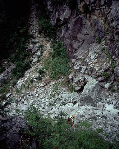
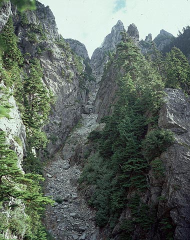
The summit area of Mt. Garfield. The main summit is on the right, the Leaning
Spire is on the left. #2 gully is the gully between them. The "key ledge" is off to the left.
The trees above the shaded slab in the lower half of the photo connect #1 gully to #2 gully.

Everyone who's flipped through the brown Beckey guide surely has heard of this mountain. The first paragraph of the
description of the mountain simply states: "Mt. Garfield is a hazardous enigma". Sounds like a kind of rock,
but it refers to the mysterious and dangerous qualities of the mountain. Such a low elevation peak, only 5500
feet above sea level. There's four and a half thousand feet of elevation gain to the summit, not overly big by
Cascade standards, but consider that you'll gain that elevation over a distance of only 1.5 miles (and the
first half mile is pretty flat). It's a steep, exposed mass of brushy rock, which presents a complex facade of smooth
rock gullies
and sinuous serrate ribs.
There was a distinct lack of information on Garfield. No one Loren or I knew had ever climbed the peak, or
really even considered it. Even with the prolific internet trip reports on personal web pages, there were
none for Garfield (save for a brief description of the route in midfork.org). So basically, it begged to be climbed, because of the aura of mystery surrounding it.
Hell, Beckey even has a detailed topo in his guide. A topo for a 4th class climb! So Garfield lured Loren
and I onto its slopes - kind of a big objective for our first time climbing with each other, but it turned out
to be a successful, stressful, fun adventure.
Almost 12 hours before the rockfall incident, we had started up the gravel wash from the Middle Fork road.
I had been this way
once before, over a year earlier, when Greg, Jeff and I made a
half-hearted attempt to scope the route out. That time, we forgot
to bring the Beckey description with us, and got horribly off route right from the start. At the junction
of the canyons, we headed right, up a brushy cliffy forested rib, instead of the obvious dirt gully. Never even
had a chance.
Loren descending to the "junction of the canyons". The dirt gully is in the background.
On this day, we quickly passed steps 1 and 2 of the climb: the walk up the gravel wash, and the forest trail that brings you
to the junctions of the canyons. We descended into the canyon, filled up on water (and a mosquito larva, as I
was to discover later).
Then it was up the infamous dirt gully that I missed last time.
The gully is loose, and slightly brushy in
spots, but doesn't exceed 3rd class (for the most part).
Near the top, a steep path heads left into forest, and reaches a knoll
before the grassy slabs Beckey mentions. I think we were less than 2 hours to this spot. Loren left his ski poles
here, hanging from a tree branch,as they were more a hindrance than a help in the brushy terrain.
The slabs above the dirt gully.
A short walk across the base of slabs brought us to an easier spot, where we started up. You get the impression
from Beckey's description that there isn't any technical or exposed areas before the "key ledge", but this section
of slab was bordering on 4th class. It is solid scrambling, but somewhat mossy in spots. After 300 vertical feet
of this, we reached the trails, and in due time located a path through the brushy forest. So far, we had been
travelling through the morning mist - it was rather surreal, especially the slabby section.
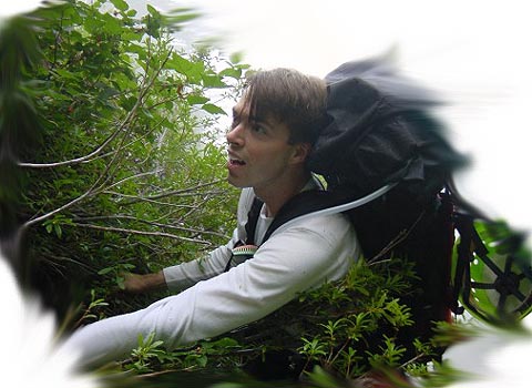
Phil "scrumbling" out of a gully through brush.
photo by Loren Campbell (blurriness by Phil)
The next hour is all a blur now. We tried to identify features mentioned in Beckey's topo, but it was somewhat
futile. We thought we had passed the razorback, but then came to a short, very serrate rock crest much later, that
definitely looked "razorback-ish". We also descended into the next gully to the west,
and followed a nasty side branch
back out - it sort of coincided with Beckey's description, but not really. The best thing to do here is just to
follow the path and orange/yellow flagging tape. It generally takes the easiest route, and we avoided having to
drop into that gully on the descent.
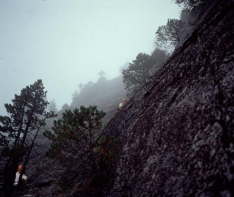
Loren tries to catch a glimpse of the upper peak.
Occasionally, we'd be on the crest of the rib, and catch glimpses of the upper reaches of the peak through the
mist - very nice, but we wanted to see more!
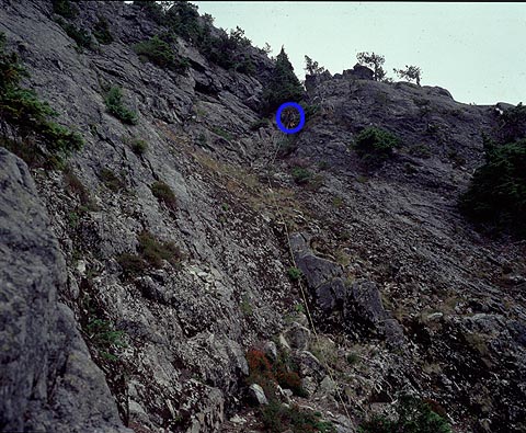
Is this the "razorback"?

We arrived at what we thought was the gladed saddle before the key ledge. It had a spectacular view of the rest
of the route. Didn't seem to be any key ledge nearby, so we ventured on, still on a path. Then we got to what
was definitely the gladed saddle. There is a nice flat, small bivy spot here. It's a tiny island of friendly
forest, in an exposed little perch.
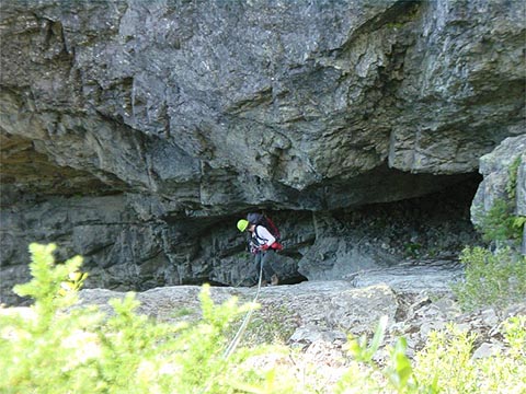
Phil approaching a step in the rock gully photo by Loren Campbell

Loren tops out on the step

The next sections of the description: 1) rock gully, 2) slanting forest ramp, 3) key ledge traverse (fatal slip has happened
here), and 4) exposed cliff traverse to reach #2 gully. After over-analyzing the Beckey description for years, I was
excited to see what it would really be like. We roped up, with kiwi coils, relying on the trees we passed
to stop any potential fall. The first three sections kind of blend together. I couldn't tell the difference,
although there were a couple of class 3 rock steps - guess that must have been the rock gully. Except it's in
a foresty ramp. Then the ramp lays back in angle, and you begin traversing more horizontally. The exposure
below you is a big drop, but somewhat unseen - there are usually trees or small bushes in the way - but slide through
them on the steep slippery duff, and maybe you're toast.
Looking down from somewhere along the "key ledge" traverse.

The rope made the traverse fairly non stressful, and we moved quickly, despite rope drag. Crossing the #1
gully, the route is exactly as Beckey describes: drop 10 feet, then an exposed cliff top traverse. In 30 feet,
you are back in the trees. #2 gully isn't right there - you need to keep traverseing up and right through brush
for a couple more hundred feet - then you emerge into the #2 gully slabs.
Looking up the #1 gully from the "key ledge" traverse
The gully far above looked quite steep - but we knew (hoped) that the foreshortening effect was just playing with
our minds. We continued up nice firm, smooth class 3 slabby terrain. This was fun relaxed scrambling.
We gave each other pseudo-belays at two steeper sections, and placed a few pieces of pro. We thought "oh, these
must be the two 4th class gully steps Beckey mentions". Ha ha ha ha!
Loren leads a short step in the #2 gully.

Eventually, we had untied the coils and were using the full rope. I led off up the right side of the gully, avoid
the center where it looked like it got more difficult in a bit. The higher I got, the more I committed ourselves
to leaving the gully. I thought I would be able to traverse back in higher up, but the option looked less and less
desirable as I got closer. The slabs were slick, and steepening. I realized I had got quite a bit of exposure
beneath me - I was probably more than 100 feet above Loren with no pro in, and the terrain had gone from easy 3rd, to 4th, with
occasional loose blocks and slick dirty spots.
At a safer spot, I was able to finagle in a chock into a crack on a horizontal ledge. It looked lame, but it was
the only thing around. I continued up another 20 or 30 feet to the beginning of a treed section - but safety still
wasn't quite there. Once I wrapped a sling around an extended, questionable branch, I felt a little better.
But the brush was hiding some vertical rock, hidden from the below. I would call this "mid 4th class" - similar to
the stuff Dave and I experienced on the north face of Kent peak last winter, but
more difficult for sure.
Phil getting sketched. photo by Loren Campbell

To make things as worse as possible, my tall skinny pack was having a horrible time making it through the brush.
Above me was a rats nest of pine tree branches. These were the only hand holds I had, and I dangled
from them above big empty space, hoping they wouldn't pull free. I must not fall.
My arms grew tired as I tried to haul myself through the nest. I'd rise up, and feel something tugging me back
down. Crane my neck around, see what was caught, try again. Same thing. Figure out what was caught, try again.
After four or so tries, I had untangled everything, and I forced myself up. It was f***ing strenuous!! After several minutes
of dangling from questionable tree limbs, I finally had solid stuff under my feet. What a relief! I slung a larger,
more secure tree trunk, thankful to be out of danger. Exhausted, I brought Loren up the 250ft "pitch", where
he awarded me with the "desperate-lead-of-the-day" award. It was not over though. Loren took over, and we
wound through steep brush, still with the full 200 feet of rope between us.
Perhaps not the best idea, but it worked.
At a little forest opening, we had a break. We had to make some
routefinding decisions. Loren said he had seen the #2 gully off to the left, but it looked far down. Perhaps
we could find a place to rappel into it, but maybe it was better just to continue this way. This was the first
time in the day I began to have serious doubts as to whether we'd summit.
Loren leading out on a slabby pitch. This is where the first rockfall occured,
through a mid-4th class section
In the end, we decided to continue right and up, along a nice slabby section. Loren led again, I was still
freaked out by my first pitch. He led across on 3rd class terrain, up and right in a brushy grunty gully,
and then back left up a "mid 4th class" rock gully. This point was still less than 200 feet from me, so I was
still standing at the belay. Good thing too, because Loren set loose a large number of loose boulders, which
went crashing down the mountain. It was a huge volley of rocks all across the slab - it was good I was not on it.
Above the horrific loose section, Loren set a belay, and I followed up. The "mid 4th" section was shattered and
sketchy. A brave lead indeed.
Me coming up to the belay after the rockfall pitch. photo by Loren Campbell

Above us, we could only see brush. I continued on, and soon came to an opening. The next section looked like
decent scrambling, mostly 3rd class. I shouted the good news to Loren. After a while, the rope drag became
unbearable, and just before a short 4th class step, I stopped and reeled him in.
He led off this time - I simple sat there in a daze and watched the slack be taken up as I fed rope through my
belay device. Soon it was my turn to follow (I could barely hear him). Up more brush, then across some
nice, solid exposed 5th class slabs. Some good rock! At the small perched belay, we could see the
Leaning Spire/Garfield col in front of us, and the base of the #2 gully probably 150-200 slabby feet below us.
Loren leads off on brushy 4th class on the 5th "pitch"

A short rappel to a patch of bushes (where I girth hitch a small twig to anchor myself) then led us to a grassy ledge that traversed the slabs to the col. Loren was
only able to get one piece of mediocre pro in on the 100ft traverse, so a fall would have been bad (50 degree
slab), but luckily
it was easy.
Topo of our route next to #2 gully.

The mossy col is a nice place. The view of the Leaning Spire (a sub summit of Garfield) from here is spectacular.
The descent for the spire
involves two rappels to the col - that last of which is a 120 feet free rappel, from a prominent horn on a wildy
exposed ledge. There were no slings on it, so I don't think this spire gets climbed very often. Scary to look at.
From the col, I expected it to be a cake walk for the final 400 feet to the summit (Beckey says "easy rock and
steep heather"). Didn't look that way though.
The Garfield/Leaning Spire col, with Leaning Spire in the background.

Loren, The Man, led off again - that first pitch sketched me out for the rest of the day, I didn't want to lead
anything else! Up mossy slab, he made a high level traverse, and announced "that was a hardest
move of the day!". He was scampering across 50 degree moss. In the bushes above, he set a belay. I found an easier way up, and then tunneled through
the dense steep brush up to him. The remainder was easier - we simuled the rest of the way up with no pro
(I think), and finished off on a nice rocky ridge to the summit.
Spectacular up here! Views of steep sweeps of huge slabs everywhere. The middle fork Snoqualmie is definitely
below you, at your feet. Loren popped open the summit register and analyzed its contents. We were
curious to know how popular a peak this was. He announced with great suprise that the last ascent had been
August 12th - just a week ago!
Loren looks through a piece of history - the summit register
He then kept looking - after that, there was nothing more recent than 1998! It's possible
some pages had gone missing, since the register booklet was falling apart. But before that, in the rest of
the 80's and 90's, it looked like
about four parties a year had made successful ascents.
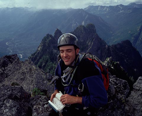
Phil, successful Garfield-summiteer. photo by Loren Campbell

Other interesting entries: "God help us on this descent!", and two entries from Pete Doorish, for big walls climbs
he made within a week of each other (one was the south east ridge, Grade V, 5.10, 20 pitches, 3.5 days?), followed
with the comment "I think that's enough Garfield for a while".
Looking up the Middle Fork Snoqualmie from the summit.

Just before 3:30, we left the summit. We scrambled down the top section, then got out one rope for the rappel
back to the col. Back at the col, we discovered the bolted rap anchors mentioned in the summit register by the
guy who installed them. Thank you! Bolts in the wilderness suck, except right at this very moment! The other
options for rap anchors, would have involved pulling the ropes down over chimneys filled with loose rock.
Descending from the summit, towards the col below Leaning Spire

We made two double rope rappels from bolts - went without a hitch. As we rapped, we had close up views of
the "normal route". The gully looked really heinous, a wide chimney for stemming, with one side overhanging,
the other side smooth moss-covered slab. The crack was periodically filled with loose debris and chockstones. It
looked really tough! Maybe it was good that we got off-route...
Loren raps from the second set of bolts.

Lower down, we traversed left across the gully slabs, and made two more double rope rappels from tree anchors. It
was shortly after this that Loren had his scare with the rockfall I described at the beginning of this article.
After this point, I noticed he was definitely
a little more "sketched" for the rest of the day, kind of like had happened to me on my first lead several hours
earlier. He didn't mention it at the time, and so I wasn't fully aware of the extent of it, but
his leg was rather injured, and becoming stiff and painful on the remainder of the descent. I, on the other
hand, am overly concerned over the stupid little flap of skin that has been shaved off by plant or rock on my thumb, and has
a speck of dirt in it. (I put two band-aids on it on the way down, but they both came off!)
Loren demonstrates the buttslide method of descent

We reversed our route back across the cliff forest ledge/key ledge traverse/forested slanting ramp/rock gully. This
time, for speed, we did it unroped, except for a short rappel in the rock gully. Without a rope, the tension was
a little higher, mistakes could not be made. But perhaps we were becoming more blas� with the continuous exposure
of this route.
I think we made it back to the glade saddle at some point between 6:30 and 7pm. I started to think of getting
back to the car in steps. Long brushy steep slopes with route-finding, then rappels at the lower slabs, then
the dirt gully, then the forest trail, then the gravel wash. I had been thinking earlier that as long as we got
back to the forest trail before dark, we'd be set. Now I was thinking, as long as we get to the top of the dirt
gully, we're fine. We can descend that in the dark.
Shortly, I began thinking we'd be fine if we just reached the slab rappels by dark. From there, route-finding
is straightforward. From our current location to that point, it would be a very grim descent in the dark - we
would probably have to bivy and wait until morning. So we set off without delay, and watched as the sun on
the surrounding peaks grew more and more colourful. We followed the flagging tape as best we could, and were
dilligent about keeping to any path. We got lost a few times, including next to a completely bogus piece of
orange flagging tape way up in a tree in the middle of nowhere.
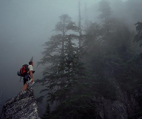
Filler picture (didn't take many on the descent) - me on the summit ridge photo by Loren Campbell

Finally, we arrived on top of the slabs. The sun was setting. We made another two double rope rappels to the
base of the slabs. My upper body was so exhausted from the climb and descent, that I was not able to pull the
ropes - my pectoral muscles were totally cramping up! I've never had cramps there before! Loren had to retrieve
all the ropes.
Ok - time for more food. It was dark now anyway, so no point in trying to rush on. Then back into the forest.
As we wound down, we lost the trail for a bit, and I had a sneaking suspicion that we'd missed Loren's ski poles,
hanging from a tree. I pointed my headlamp up the slope, and pointed out where they ought to be, although I
couldn't really see anything. Loren ambled up there - and sure enough, there they were!
Another filler picture - me on the 3rd or 4th double rope rappel in #2 gully photo by Loren Campbell
Now back into the dirt gully. Pitch black, down climbing dirty 3rd class by headlamp, grabbing onto spiny
bushes. It sucked, it sucked. Hot, beads of sweat dripping down into my eyes, tree and bush pollen, and
dirt in my face, out of water, all the cuts and scratches of the day being filled with dirt, and reirritated. The sound of
water got closer and closer. Then we reached the junction of the canyons, and f***ing water! Yes!
The stars were beautiful, the water was fresh and cold, and we could finally relax
now - it was easy back to the truck.
Or was it?
The connection from the junction of the canyons to the forest trail, is a short steep dirt ramp in dense brush.
We found it, and headed up. And up. Seemed to be going up for a long time. I called to Loren "can you see the
trail?" "No."
The next 10 or 15 minutes were very weird.
I back tracked a bit. Still no trail. I went up a bit. I went left. I went right. I became very disoriented.
No trail anywhere. Just steep, dense brush all around me, illuminated dimly by my headlamp.
Getting steeper below, above the exposed rim of the canyon. I couldn't backtrack anymore,
because I'd lost track of where we'd come from. The only clue was the sound of dripping water in the canyon below.
Loren and I regrouped and wandered around aimlessly. How could
we miss it? It was a very obvious path! Do we go up? Do we go down? Seems like its down, but seems
dangerously steep below us. But you can't tell for sure, because the brush blocks everything. Things started
getting freaky. We finally decided to just head down. Loren's headlamp was a little brighter, and could see
a little farther. Finally, below us, an inkling of a trail. Yes, this was it! What a relief... don't know how
we missed it.
Phil during the nighttime descent photo by Loren Campbell

We paid very close attention to the trail for the next while, and only lost it a couple of times. Soon,
we were back in the gravel wash, and 20 minutes later, back at the truck, and the beer. It was 11:06pm, it had
taken us sixteen hours and 20 minutes. We had done it, and now we never have to do it again! (except... there is
a cool looking gully for a winter climb... hmm...)
Thanks to Loren for a great climb!
Mid-4th class: my technical term for rock/brush combination that is roughly equivalent to mid 5th class
rock (e.g. 5.5-5.8) in overall difficulty, if not technical difficulty. Because it is not nice clean rock,
it is tempting to refer to it as just 4th class - except that belies the difficulty due to looseness, mossiness,
brushiness, lack of pro, leading to severe mental stress. Thus, it is designated as mid-4th class.
Note: In the updated version of Beckey's brown guide, the topo for the climb is no longer present. However,
there is a much better description of the route in the text. Furthermore, the technical grade of the climb has
increased from class 4 to "class 4+". That's the first time I've ever seen something graded "class 4+".
Beta
Water: no water above the junction of the canyons (below dirt gully) - I filled up and took 3 quarts up from there.
That was sufficient, but it wasn't a hot day. A hot day would be much worse. I drank about 6 quarts during the whole day.
Gear: Bring lots of slings for rappels and pro. We brought a half-dozen chocks and two #2 cams, which was a sufficient.
Some smaller cams would have been better. 2 ropes are a really good thing. You'd be hurting rapelling #2 gully
with only one. 50m sufficient.
Weather: You want dry weather, and no recent rains. Many of the slabs are mossy. Any kind of wetness would suck
on this climb. We lucked out - it was dry, but foggy for the first part of the day, so we didn't bake in the sun.
People: we almost had a third person on this trip. Even though it would be nice to meet him (and from what
Loren tells me, he would have been our rope gun), I'm glad he bailed. You really
want to do this climb with two people only,
due to the need for speed, and the loose rock danger. (talk about speed - according to the summit register,
some guy soloed the route in 3 hours car-to-summit!).
In general: be prepared for unrelenting steep rock, brush and dirt, the whole way up. Yeah, it's an adventure!