
Eldorado Peak - North Ridge. September 29-30, 2001.
Time for another Fall extravaganza on Eldorado. Dave and I were interested in checking out the northwest couloir, a late-season water ice climb. I wasn't convinced it would be in shape though, and thought the north face of Spider Mountain might be a nice alternative. However, we got some beta on a potential backup plan near Eldorado if the NW couloir didn't work out, so Eldorado it was.Saturday morning on the drive to the trailhead, Dave and I were witness to one of the most amazing sunrises I've ever seen. A common photo people take back from high places such as Rainier, is the image of the shadow of the mountain projected onto the valleys and clouds below. This morning however, the rising sun was projecting the mountains onto the sky, which was composed of orange clouds. Cool! As we got closer to Marblemount, we realized we could see the north face of Eldorado - it looked steep, dark, snow-dusted, scary. The couloir itself was hidden.
Mountain shadows projected onto the clouds
I was aware of the "reverse Pulp Fiction syndrome" on this approach. Everyone told me what a great movie Pulp Fiction was, so my expectations were really high when I saw it. Thus, even though it was a good movie, I was disappointed. It was similar to the Eldorado approach. When I first did it last year, everyone I talked to said how brutal it was. When it turned out to have a nice trail, and no bushwhacking, I was like "wow, that was easy!". So I had it in my head that it was easy... and so this time I was worried that I would find it much tougher. Kind of like, if I saw Pulp Fiction again, I would probably think it was really good. Anyway...
The drive down Cascade River Road was somewhat worrisome when my truck starting making buzzing bee sounds. Driving with the window open, I was able to ascertain that the sound was coming from the front driver's side wheel. I stopped and look at the wheel. Didn't see anything out of the ordinary. I started driving again. No more buzzing. Then, a minute later, the buzzing again, the beat of which was directly proportional to the speed of the truck. I stopped. I started again. No more buzzing. Then - more buzzing! We tried to ignore it, while fully expecting the wheel to come flying off, and were relieved when we made it to the parking lot a few miles later.
The hike up was uneventful, other than for one thing. Ok, two things. The first, was a large avalanche of some kind of Johanesburg. I've spent maybe 10 days in the vicinity of Johanesburg, and this was by far the largest event of that kind I've seen. We heard the roar, not the first that morning, and looked over, not expecting to be able to pick anything out from this distance. Instead, we saw a huge amount of "stuff" pouring over the 800ft vertical cliff at the base of the north face. Snow avalanche? The thing is, it kicked up some kind of spray, and it didn't seem to pile up on the valley floor, and there were no big chunks in it. So this makes me think it was water - some kind of "outburst flood" from the glacier near the top of the face? It went on at a full roar for 20 or 30 seconds, like Niagara Falls was transported to the Cascades - it was huge! And then it continued for another 2 minutes before drying up. Must have been an amazing sight from the Cascade Pass parking lot!
Mt Johanesburg. The huge water avalanche poured over the cliff visible at bottom left.

The other notable thing from the approach was the blueberries - mmmm!
The hike from 2100ft to our 7500ft camp at the base of the east ridge took just over 5 hours. The Eldorado Glacier was notably more crevassed than last year at this time. In fact, where we camped last year was now a jumble of yawning crevasses! There wasn't a whole lot of new snow up there - probably just a couple of inches, wind-scoured so it was bare in most spots, deep in others. The striking thing was the degree to which crevasses had been covered. Cracks up to two feet wide were covered in a smooth layer of snow that would collapse with the swing of an ice axe. Luckily the fresh snow had been swept clear of the areas around the crevasses, so they were still plainly visible as streaks of brighter white. But if another few inches of snow fell without a wind, these man-eater-size crevasses would be completely concealed!
Crevasse covered with a few inches of fresh snow.

Just as we got to camp, the occasional sprinkles turned to rain. We quickly set up the tent and got inside - lucky for Dave, as all he had to wear was his less-than-waterproof schoeller jacket! The cloud deck, which had been at about the level of the highest peaks, came down bit by bit. Shortly after, Dan Aylward and two friends arrived and suprised us by walking up and shouting in our tent - for a second, Dave and I thought it was the strangers we met down at the parking lot, and we thought "wow, they're obnoxious!".
The Torment-Forbidden ridge. Forbidden is in the center, summit in the clouds. Torment, on the right, looks like it has some nice ice on its north face.

The three had come to do the West Arete of Eldorado. They had intended to continue further before camping, but the clouds had descended enough that we were in a whiteout, and the glacier navigation would be pretty tough. They found a spot protected by the wind and set up camp.
Dave pulling some moves.
The rest of the day was cold, damp and windy. Kind of nasty. We stated in the tent and played Rock, Paper, Scissors. I totally kick ass at that game!
Clouds breaking up over the south face of Eldorado
The night was long and nearly sleepless for me. Don't know why. Dave woke up in the middle of the night and went out to pee. He said he had been having non-stop peeing dreams. Then I realized, during a short spell of sleeping, that I had just dreamed that I was trying to find snow to melt for water, but someone had peed over every patch of snow! I resolved to set Dave straight in my next dream.
We heard Dan and company wake up and leave at 3am. I knew that our alarm would go off two hours later. I managed to sleep a little more, but then started getting scared about the climb. I couldn't sleep. Seemed like a long time since Dan had left though. I went outside to pee. The sky seemed to be getting brighter. Had we missed the alarm? Indeed we had, it was 6:20!
We headed out of camp just before sunrise. The night had gotten cold when the skies cleared, but you could tell it was quickly warming up. The forecast 13000ft freezing level did not sound good for ice. We followed Dan's track across the Inspiration Glacier. The travel was tedious - lots of end-running and a few small crevasse jumps - it would have been fun if we weren't trying to get somewhere! We were either going to try to cross over to the McAllister Glacier, and from there descend into the Marble Creek drainage, or attempt to descend directly into Marble Creek from the Inspiration - from the map, it looked like it might be feasible with a rappel or two, and it could save a lot of time, especially with the condition of the glaciers.
A rather broken up Inspiration Glacier.

In the end, the crevasses sort of dictated we attempt our direct route, and we made our way over to a col between Eldorado and Dean's Spire. The anticipation was great as we neared the edge - what would the couloir look like? Would we even be able to see it? With andrenaline rushing, we ditched the crampons, scrambled up on some rocks and peered over...
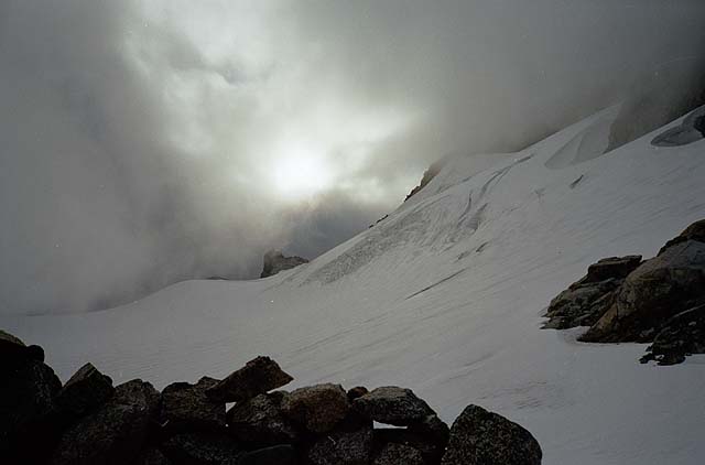
The north side of Eldorado presents one intimidating alpine facade! Cold, dark, steep, snowy. The couloir is the most notable feature of the face. It's quite deeply entrenched, and quite hidden. We couldn't see into much of it, but it was obvious to us that it "wasn't in shape". At least for our skills. The entrance was guarded by a large chunk of perenial snow, that appeared completely vertical. There didn't appear to be much water ice in the couloir.
The NW couloir of Eldorado on September 30 - only the bottom portion is visible, but you can tell where it goes.

We found a dirt gully and scrambled down to get a better view. Couldn't see much more. You really need to descend into the Marble Creek drainage to get a good look at it. Anyway, no matter, there was no way we were going to climb it today. As for approaches, it looked like you might be able to get down from this col. It's about 400ft of rock before you hit the glacier below - some of that could be down climbed, but you'd need to do a few rappels too.
Back at the col, we decided what to do. Our backup plan, a peak out on the McAllister glacier that Jim Nelson had mentioned, seemed like a long ways away. Dave had earlier suggested the southwest ridge as a potential backup (it looked a little like the east ridge of Forbidden Peak), but that was on the other side of the mountain.
The north ridge. We turned the bottom part on ice and ledges on the opposite side, then followed the rock crest up higher.

Instead, the ridge above us - the north ridge I suppose - started looking pretty sweet. It didn't look too tough, except for a steeper section above. The rock looked good, and, most importantly, it was in the sunshine. The ridge parallels the Northeast face (a short ice climb which looked pretty broken up), sometimes separated from it by a moat. Though you could veer back and forth from ridge to ice face quite often, we thought a route as much as possible along the rocky crest would be fun, and we decided to make it a little more sporting by climbing it in our crampons.
We began simulclimbing - I led up a half pitch of 50 degree ice, and weaved around some crevasses to the ridge proper. Here Dave took over, and climbed up onto the rock. He encountered a step which provided some difficulty. Easy in rock shoes maybe, but not crampons. He tried to aid off a sling, but the only spot to attach the sling, didn't give him enough reach. Finally he just went for it, got a good hand jam, and hoisted himself up. He set a belay for me to follow.
Dave negociates a step on the ridge.

We continued simulclimbing on easy class 3 and 4 terrain for several hundred feet, sometimes veering into the moat for a few ice climbing moves. There was the occasional loose block, but overall the rock was solid and trustworthy, with lots of cracks. Finally we arrived at the steep step in the ridge. We took off our crampons for this more difficult-looking section, and Dave took the lead again. It turned out to be a pleasant full pitch on solid rock, probably about 5.5. The snow-covered ledges made things a little interesting, and travelling right along the crest made for some exciting exposure, with the northwest face dropping off steeply to the right.
A look into the NW couloir from the north ridge. The end of our route marked in yellow.

Dave high on the ridge. The col by which you access Marble Creek from the Inspiration Glacier is visible in the background. It looks like the route on the rocky crest from here over to Dean's Spire would be a sweet ridge-run (in rock shoes)

After this section, the ridge mellowed considerably. We arrived atop the exit from the NW couloir, a couple of hundred feet below the summit snow arete. Here the crampons went back on, and the ice tools came back out. We could see the top section of the couloir - it was glazed with about an inch or two of ice. We thought about setting up a top-rope and climbing a bit of it - I don't know why we didn't! I guess we were anxious to summit.
Me on the upper ridge. photo by Dave Burdick

Me climbing the final ice slope. photo by Dave Burdick

Dave climbs up to the summit ridge.

I wasn't paying attention, and forgot to lookup, so I missed the actual summit by about 50 feet. I straddled the ridge crest and put in an ice screw for a belay. Rotten ice - not secure at all - so when I brought Dave up, I was ready to hop off the south side of the mountain in case he fell! The summit ridge was a lot softer and easier than last year. We walked over to the rocks and relaxed in the warm sun. What a great, satisfying climb. What an amazing spot! What a beautiful summit!
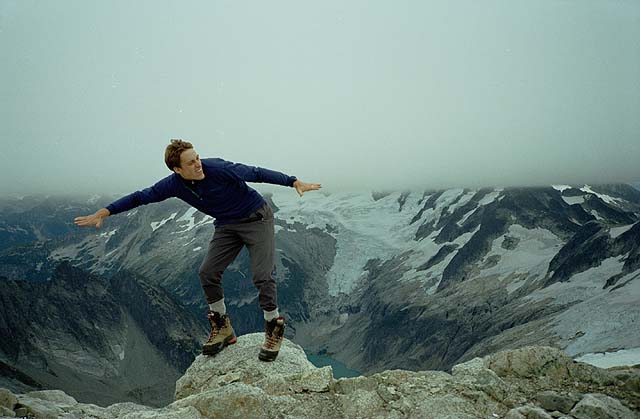
Dorky summit shot.

Time to go down. The snow on the south/east face was kind of sucky. A good amount of fresh snow on top of ice. We followed a path along the boulders on the south face instead, occasionally veering onto the snow, where our crampons would ball up, and Dave would send avalanches down on me. There was a good foot to foot and a half of fresh slush here!
We got back to camp 40 minutes later, and did some more relaxing. And then - something really creepy!
I looked up to the south face of Eldorado. I couldn't believe what I saw! Fred Beckey in the rock! It was a carbon copy of the image of Beckey from the back of the red Cascade Alpine Guide - just staring at us from the base of the south face. I pointed it out to Dave, and he freaked! The likeness was amazing. We felt like the climber versions of religious zealots who see the Virgin Mary on the side of a church or something.
The Virgin Beckey

We reached the truck three and a half brutal hours later - made slightly less brutal by finding the right paths through the talus field between 4000 and 5000ft. Essential! The buzzing in my wheel had stopped.